
High-Level Project Summary
Because of solar storms, high temperatures reach the ground And Because of the high heat a high free wave is formed and Due to heatwaves produce wildfires and reduced yields and Because of the high temperatures the ice sheet starts to melt And Because of the melting of the ice sheet, the water level starts to rise and produces floods and high waves and Because of solar storms, high temperatures reach the ground.
Link to Final Project
Link to Project "Demo"
Detailed Project Description
In the beginning, we chose the topic of how the climate affects us, then we chose one of the main factors contributing to climate change, which is solar storms due to the occurrence of solar storms. Then we discussed the reasons for the occurrence of these effects, and finally some statistics recorded for these effects
Space Agency Data
Image
Wildfire is an essential process connecting terrestrial systems to the atmosphere and climate. As vegetation burns, it releases smoke, carbon, and other materials into the atmosphere. These fires also release nutrients into the soil and are an integral part of ecological succession, plant germination, and soil enhancement.
NASA's Earth Science Data Systems (ESDS) Program provides unrestricted access to data, services, and tools that enable resource managers, disaster management teams, and scientists to understand and monitor environmental conditions before a fire starts, measure the intensity and development of fires during a burn, and assess the environmental and socioeconomic impacts after a burn. Additional resources are available through NASA's Applied Sciences Wildfires program area and other agency initiatives.
Image
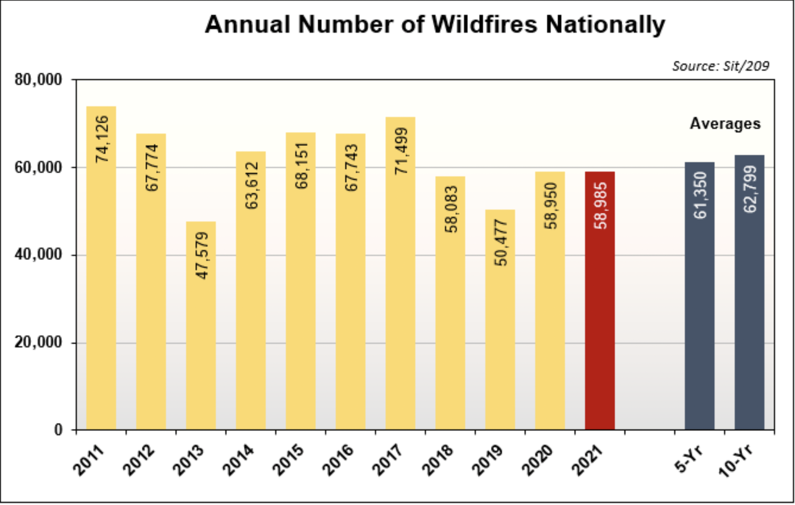
The number of U.S. wildfires in 2021 (red bar) was slightly lower than the 5- and 10-year averages (blue bars on right). Click on image for larger view. Credit: NIFC.
The number, severity, and overall size of wildfires has increased, according to the U.S. Department of Agriculture, through contributing factors including extended drought, the build-up of fuels, past fire management strategies, invasive species targeting specific tree species, and the spread of residential communities into formerly natural areas. In 2021, 58,985 wildfires were reported across the U.S. that consumed 7,125,643 acres, according to the 2021 Annual Report by the National Interagency Coordination Center (NICC). But wildfires also have a human component, and the NICC report notes that "a total of 5,972 structures were reported destroyed by wildfires in 2021, including 3,577 residences, 2,225 minor structures, and 237 commercial/mixed residential structures. In 2021, California accounted for the highest number of structures lost in one state: 2,031 residences, 196 commercial/mixed residential structures, and 1,136 minor structures."
Along with near real-time wildfire data available through NASA's Fire Information for Resource Management System (FIRMS, described below), current U.S. wildfire statistics are available through the National Interagency Fire Center (NIFC).
NASA’s climate website has resources pertaining to many aspects of climate science and climate change
NASA’s Applied Remote Sensing Training Program (ARSET) Climate Trainings can be found here
NASA ‘s Earth Science Division uses global observations from space, air, sea, and land to help us better understand our planet’s interconnected systems
The NASA Earth Exchange (NEX) platform provides the Earth science community with a mechanism for scientific collaboration and knowledge sharing
NASA’s Earth Data site provides full and open access to NASA’s collection of Earth science data for understanding and protecting our home planet
NASA Worldview enables users to visually explore the past and the present of our dynamic planet from a satellite's perspective
NASA’s Applied Sciences Program helps partners use NASA's unique view from space to address real-world issues, including climate change
Hackathon Journey
My trip in the hackathon was fun. We worked together with friends and the supervisor. Team spirit was our foundation. We spent a long time to complete this project. We thought a lot about the project and our challenge was a very wonderful challenge
References
- NASA Climate Change
- NASA’s climate website has resources pertaining to many aspects of climate science and climate change
- NASA ARSET Climate Trainings
- NASA’s Applied Remote Sensing Training Program (ARSET) Climate Trainings can be found here
- NASA Earth Science
- NASA ‘s Earth Science Division uses global observations from space, air, sea, and land to help us better understand our planet’s interconnected systems
- NASA Earth Exchange
- The NASA Earth Exchange (NEX) platform provides the Earth science community with a mechanism for scientific collaboration and knowledge sharing
- NASA Earthdata
- NASA’s Earth Data site provides full and open access to NASA’s collection of Earth science data for understanding and protecting our home planet
- NASA Worldview
- NASA Worldview enables users to visually explore the past and the present of our dynamic planet from a satellite's perspective
- NASA Applied Sciences
- NASA’s Applied Sciences Program helps partners use NASA's unique view from space to address real-world issues, including climate change
OTHER EXAMPLE RESOURCES
- Fourth National Climate Assessment
- The Fourth National Climate Assessment, released in 2018, provides regional climate information for the U.S.
- U.S. Climate Resilience Toolkit
- The U.S. Climate Resilience Toolkit provides climate change information and tools to build resilience to climate change.
- Socioeconomic Data and Applications Center
- NASA’s Socioeconomic Data and Applications Center (SEDAC) focuses on human interactions in the environment, and serves as an "Information Gateway" between Earth sciences and social sciences.
- LandsatLook
- The LandsatLook Viewer tool allows rapid online viewing and access to the USGS Landsat Collection 2 data.
- Land Process Distributed Active Archive Center (LP DAAC)
- The NASA Earth Observing System Data and Information System Land Processes Distributed Active Archive Center (LP DAAC) processes, archives, and openly distributes land data products.
EUROPEAN SPACE AGENCY (ESA)
CANADIAN SPACE AGENCY (CSA)
- CSA Taking Action on Climate Change
- This CSA page details how the agency is helping support data-driven decisions on climate change action.
- Climate Change Services and Information (Canada)
- This is the Government of Canada's hub for climate change information.
MEXICAN SPACE AGENCY
Tags
#alamal jupiter