Awards & Nominations
baybayin has received the following awards and nominations. Way to go!
Global Nominee

baybayin has received the following awards and nominations. Way to go!
Coastal degradation poses a looming threat to communities residing along shorelines as it could cause heavy damages to the unprepared as well as damage the ecosystem and loss of land. Using image and sea current data accumulated by various satellites, we developed a web - based app that can warn the respective LGU of an observed rapid coastal degradation in their community, show visual representations of these degradations, and help in deciding the best approach in solving the problem through simulation.
Coastal erosion is often overlooked until the community is devastated by its effects, that’s why it is important to provide visual representations of coastal degradation to bring awareness to it and to provide possible solutions to respective areas in order to mitigate its ever present effects.

The Philippines as an archipelago have a lot of coastline to deal with. Coastal accretion and erosion affects the shape of present coastlines. However, because of human intervention and activities, coastal erosion has been intensified.

The scale and impact of this problem is both expected to become more widespread due to climate change. If nothing is done to address this issue, it would result in the loss of a larger area of land economically and/or with ecological value.
The Mining and Geoscience Bureau of the Philippines is responsible for monitoring and reporting on coastal hazards. In partnership with the Local Government Unit to establish danger areas for possible erosion.

Baybayin is a web application that can warn communities susceptible to coastal degradation by showing visually the erosion that has occurred all throughout the years by highlighting the present state of a coast and comparing it to its preceding years, this may also show the rate at which erosion is occurring. With this we can bring awareness to coastal communities and have them take the appropriate actions, and advise counter measures in order to mitigate coastal degradation through the use of a wave simulator integrated with the web app.
 FEATURES
We are a group of individuals with the same goal in mind: to provide a feasible solution to a specific problem in which people from our community can benefit. After (thinking long and hard together) brainstorming, we thought that here in the Philippines there isn’t much noise regarding coastal degradation and its adverse impact on affected communities, and so we thought about contributing to that field. We’ve come across a lot of difficulties but we managed to collaborate and persevere as a team and have made something that we can be proud of.
Special thanks to the organizers for making this amazing event possible and for handling all of the participants' needs and provisions. Also a huge thanks to the mentors that advised us and gave us pointers into making this project.
This is Preus Prixor Manulat- BS in Computer Engineering, Titus Leo Ligutom- BS in Computer Engineering, Trisha Mae Juntado - BS in Computer Engineering, Al Raffy Sarip- BS in Computer Engineering, Kayle Daniel de Azis- BS in Marine Biology; geared towards helping the community and its environment thrive against ecological problems by providing sustainable solutions!
Related Literatures
Knutsen, A. (2018, April 25). Meet Celeris, the first interactive coastal wave modeling software that runs faster than real-time. USC Viterbi | School of Engineering. Retrieved October 2, 2022, from https://viterbischool.usc.edu/news/2018/04/celeris-the-first-open-source-interactive-coastal-wave-modeling-software-that-runs-faster-than-real-time/
Bayani, J. K. E., Dorado, M. A., & Dorado, R. A. (2009). Responding to Sea Level Rise - A Study of Options to Combat Coastal Erosion in The Philippines. EEPSEA Policy Brief pb2009082, Economy and Environment Program for Southeast Asia (EEPSEA)
Feature: Understanding shoreline changes in the Philippines. (2017, March 31). Republic of the Philippines, Dept. of Environment and Natural Resources, Mines and Geosciences Bureau. Retrieved October 2, 2022, from https://mgb.gov.ph/2015-05-13-02-02-11/mgb-news/503-feature-understanding-shoreline-changes-in-the-philippines
Coastal and Marine Protected Areas. (n.d.). Philippine Clearing House Mechanism. Retrieved October 2, 2022, from http://www.philchm.ph/coastal-and-marine/
Nico. (2016, November 18). Coastal Hazards in the Philippines. Earth’s Revenge. https://elanlwekatara.blogspot.com/2016/11/coastal-hazards-in-philippines.html
Aryastana, P., Ardantha, I. M., & Candrayana, K. W. (2018). Coastline change analysis and erosion prediction using satellite images. MATEC Web of Conferences, 197, 13003. https://doi.org/10.1051/matecconf/201819713003
Amaro, V. E., Gomes, L. R. S., de Lima, F. G. F., Scudelari, A. C., Neves, C. F., Busman, D. V., & Santos, A. L. S. (2014, June 19). Multitemporal Analysis of Coastal Erosion Based on Multisource Satellite Images, Ponta Negra Beach, Natal City, Northeastern Brazil. Marine Geodesy, 38(1), 1–25. https://doi.org/10.1080/01490419.2014.904257
van Rijn, L. (2011, December). Coastal erosion and control. Ocean & Coastal Management, 54(12), 867–887. https://doi.org/10.1016/j.ocecoaman.2011.05.004
Prasad, D. H., & Kumar, N. D. (2014). Coastal Erosion Studies—A Review. International Journal of Geosciences, 05(03), 341–345. https://doi.org/10.4236/ijg.2014.53033
DATA SOURCE
Sea Surface Currents (Zonal & Meridional). (n.d.). NASA EOSDIS Worldview. Retrieved October 2, 2022, from https://worldview.earthdata.nasa.gov
Landsat Collections. (n.d.). Earth Engine Data Catalog. Retrieved October 2, 2022, from https://developers.google.com/earth-engine/datasets/catalog/landsat
Sentinel Collections. (n.d). Earth Engine Data Catalog. Retrieved October 2, 2022, from https://developers.google.com/earth-engine/datasets/catalog/sentinel
IMAGES
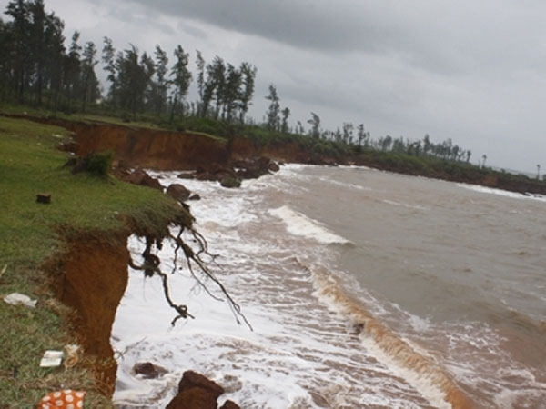
http://img.cdn2.vietnamnet.vn/Images/english/2015/09/07/10/20150907100305-erosion.jpg
#coast #erosion #philippines